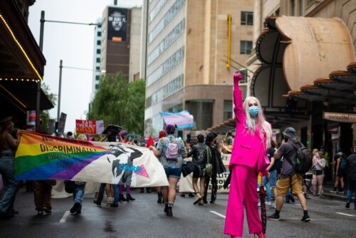
For this collaborative research project we worked with the Youth Justice Coalition (YJC), a South Los Angeles community organization. During the spring of 2011, we came together to understand how gang injunctions work as a tool of racist spatial regulation and management. YJC runs a youth community center and an alternative high school for system-involved youth, the FREE LA High School. YJC organizes locally and nationally to challenge prison and police expansion and to abolish suppressive policing tactics such as gang injunctions and truancy tickets. One of YJC’s current projects is the 1% Campaign, a campaign that demands one percent of the law enforcement budget go to funding youth jobs, community centers, and paid gang intervention workers as an alternative to policing and incarceration.
During the time of our research project, YJC was planning to file a class action lawsuit against the City of Los Angeles to contest the curfew clause of gang injunctions, which impose a curfew (in some cases as early as 6 pm) on individuals named in the injunction. A gang injunction is a civil restraining order filed by the city attorney against named individuals that restricts those individuals from engaging in particular activities (legal and illegal). The gang injunction also defines a geographic area over which the injunction is enforced. Injunctions restrict named individuals from engaging in otherwise legal activities, such as being at certain intersections or public parks, associating with other named individuals on the injunction, or being outside between certain times of the day. Some injunctions do not name specific individuals but only name a geographic boundary of gang activity in order to propose increased law enforcement in that area.
Currently there are 46 gang injunctions in Los Angeles that apply to 72 neighborhoods. The geographic area that gang injunctions cover range in size from a few blocks to sixteen square miles. 1 Gang injunctions disappear the question of the “who” of criminalization, a question that has historically been at the center of various kinds of activism and advocacy efforts, into the “where” of crime hotspots. This putatively race-neutral mode of representing crime is anything but; in L.A. gang injunctions function as tools of data-mining information on Black and Brown youth, which is then used by law enforcement to track, trap, and sometimes kill primarily Black and Brown young people. 2 The fact that injunctions operate at the scale of the neighborhood means that injunctions can simultaneously exploit the criminalized relationship of racialized masculinity to law and order, while their operation targets whole neighborhood populations, thereby unraveling binary modes of gendered criminalization. Gang injunctions exert a force on residents’ movement through space and a vulnerability to criminalization that confuses normative gender roles and relationships. The effects of injunctions underscore how racialized and classed precarity mark the site of gender’s un-doing, revealing how racialized and classed communities are always already rendered as gender deviant.
Background
The first gang injunction in the city of Los Angeles was filed in 1987 by then City Attorney James Hahn against the Playboy Gangster Crips in the West Los Angeles Cadillac-Corning neighborhood. Gang injunctions are part of a sustained strategy to regulate and control urban space through the management of crime. By the 1980s, Los Angeles was in the midst of an economic and political crisis after experiencing a period of economic growth after World War II and into the 1970s. The passage of California Proposition 13 in 1978 placed a considerable strain on state and municipal tax revenues, and the industries that had employed modestly educated working-class people relocated, pushing people out of the formal economic sector. Law enforcement responded to the growth of networks of illegal economic activity using legal prohibitions and collaborative policing in a purported War on Drugs and a War on Gangs, which criminalized gang membership and funded intelligence collection and cross-departmental collaboration aimed at suppressing gang activity. Along with gang injunctions, the War on Gangs included the establishment of the 1987 Gang Reporting and Tracking System (GREAT), an LA County database designed to track alleged gang members; the 1988 Street Terrorism Enforcement and Prevention (STEP) Act, which was the first piece of legislation that criminalized gang membership; and the CalGang Database. The STEP Act defined gangs as a category of terrorist organization and created enhanced prison sentences for people labeled as gang members.
The War on Gangs represented a refinement of the War on Crime that had flourished in postwar Los Angeles. The War on Crime, beginning in the late 1930s and spearheaded by LAPD chief William Parker during his tenure from 1950 to 1966, reinforced the racial boundaries of the city. The War on Crime re-tooled the capacity of the LAPD, which was built on suppressing organized labor, towards the end of maintaining social order and reflected some of the reformatory concerns of a growing middle class in Los Angeles. Throughout the 1970s and early 1980s, public consent for policing reached a breaking point in Los Angeles. Various groupings of people used organizing, direct action, protests, lobbying, and legal activism to challenge the legitimacy of the LAPD’s violent policing tactics. Issues that resonate with activists today were at the forefront of political efforts in post Watts Rebellion Los Angeles: LAPD spying and surveillance of political organizations, LAPD choke hold deaths, shootings of unarmed civilians, and racial profiling in traffic stops. One of the most sustained local anti-policing efforts, the Coalition Against Police Abuse (CAPA) attempted to organize various neighborhood organizing committees and grassroots and progressive organizations in Los Angeles to challenge the legitimacy and constitutionality of the LAPD’s policing practices. Public dissent against policing smoldered in the 1980s following the 1979 LAPD shooting of Eulia Love. Liberal and progressive organizations sought to scale up their efforts by forming the Citizen’s Commission to End Police Repression in 1980. CAPA contributed directly to the formation of the Citizen’s Commission on Police Repression, which mounted a left to liberal challenge against the LAPD, campaigning for civilian oversight of the LAPD, a measure that did not pass. The War on Gangs functioned as a temporary resolution to the LAPD’s legitimacy crisis: honing in on violent crime, and discursively linking gang affiliation to terrorism, created a problem that only law enforcement could solve.
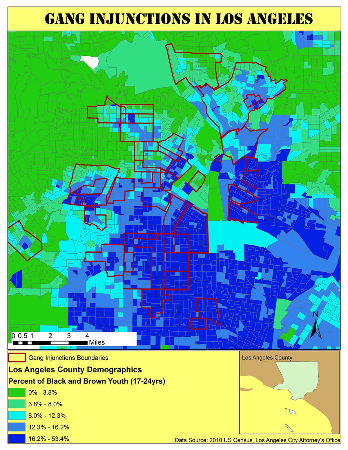
This map shows the boundaries of injunction zones alongside 2010 Census data that shows the percentage of Black and Brown youth (aged 17 to 24) by block. All but one injunction zone pictured encloses one or more blocks with high concentrations of Black and Brown youth.
The development of data information technology has been a companion to the development of policing techniques and in particular, the War on Gangs. Since the mid-1990s, Geographic Information Systems (GIS) and other data driven policing approaches have found increased usage in the material and ideological production of the prison-industrial complex (PIC). California was one of the first states to create a GIS dataset that included prisons, youth facilities, and prisoner populations for corrections and urban planning usage. 3 GIS is used to track and place people within prisons, to visualize cell vacancies and occupancies, and to control contact between particular groups of prisoners. It is also used by probation and parole departments to assign and manage cases and to monitor people under various forms of state supervision. 4 GIS is used by crime analysts to map crime “hotspots,” and to help make determinations about how to distribute law enforcement capacities and resources. 5 GIS is also employed as a public relations tool by law enforcement to promote awareness among community members of reported crimes in their neighborhoods. For example, the LAPD’s crime analysis department, Compstat, maintains an online mapping interface that allows web users to map and view crimes in Los Angeles neighborhoods. Users can input time intervals that they want to map, focus on particular neighborhoods, and choose which categories of crimes they want to view.
Beyond the state use of GIS to manage the material infrastructure of the PIC, GIS also helps to normalize prisons, policing, and state-sanctioned violence by representing space as that which is to be managed, defined, and controlled by planners, policy-makers, and researchers, whose investments, privileges, and relative positions of power are rendered transparent. 6 Mapping is a form of representation that helps to reinforce common-sense ideas about people and places. Michel de Certeau argues that space is a “mobile entity that is produced as it is practiced.” 7 As a social product, space is also a tool of thought and action, as well as a means of production, a means of control and domination, and a means of power. 8 Corrections-oriented GIS projects underrepresent the social, economic, and political contexts in which geographies of violence emerge and persist. While the use of GIS for reentry mapping and policy evaluation may produce more sensible policies for resource distribution and service siting, these projects also overrepresent incarceration, surveillance, and suppressive policing tactics as viable and sustainable strategies for producing and maintaining public safety.
Methods
For this project, we met with students, staff, and youth organizers interested in using GIS software and maps to visualize how gang injunction policing disproportionately impacts youth of color. First, we used the Los Angeles Times online homicide report to create a database of reported homicides between 2007 and 2011 that included the race, gender, age, and location of each person whose murder was reported. We also noted which homicides were the result of law enforcement use of deadly force. YJC continued this project by supplementing the data with information from the coroner’s office obtained through a California Public Records Act Request to produce a report titled “Don’t Shoot to Kill: Homicides Resulting from Law Enforcement Use of Force Within LA County, 2000-2014.” 9 The report includes a database documenting every person killed by law enforcement use of deadly force between 2007 and 2014.
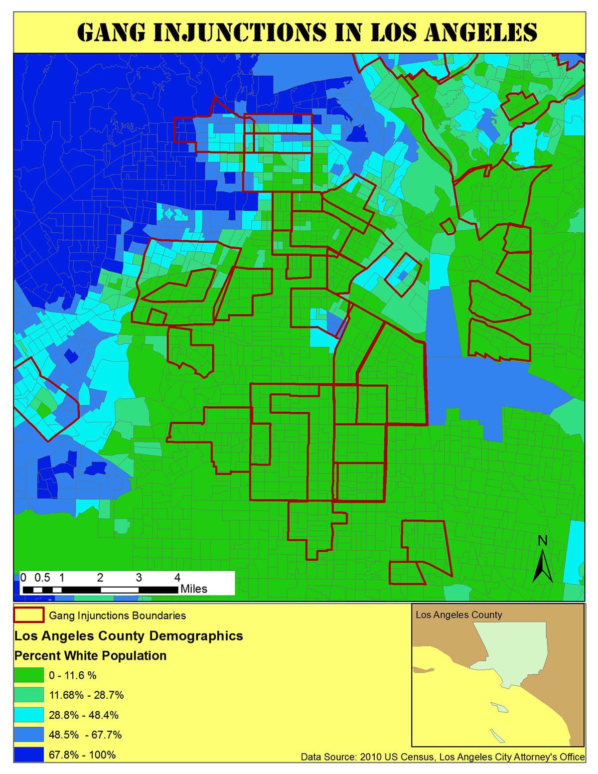
This map shows the boundaries of injunction zone in Central Los Angeles alongside 2010 Census data that shows the percentage of White people by block. This map underscores how injunctions are used to target communities of color, particularly Black and Brown communities and to enforce long-standing spatial patterns of racial and ethnic segregation.
We also used ArcGIS to create a shapefile of the 46 gang injunction boundaries so that we could map them alongside other features. We mapped the gang injunction boundaries alongside 2010 Los Angeles County census data to understand the extent to which injunction zones were mapped across historical and current racial boundaries. We ran the homicide database through an address match program so that we could map each individual reported homicide and create a density surface of the injunction zones to understand to what degree gang injunctions have been effective at curbing violent crimes. We also mapped the injunction boundaries alongside homicides resulting from law enforcement use of deadly force, to understand whether or not such homicides were more prevalent in injunction zones. Additionally, we used a spatial video console to record youth organizers’ spoken narrative accounts of neighborhood change while driving through two injunction zones: one injunction zone in the Hyde Park neighborhood, near the YJC’s school and community center, and another injunction zone that encompasses the Mar Vista Gardens Housing Project.
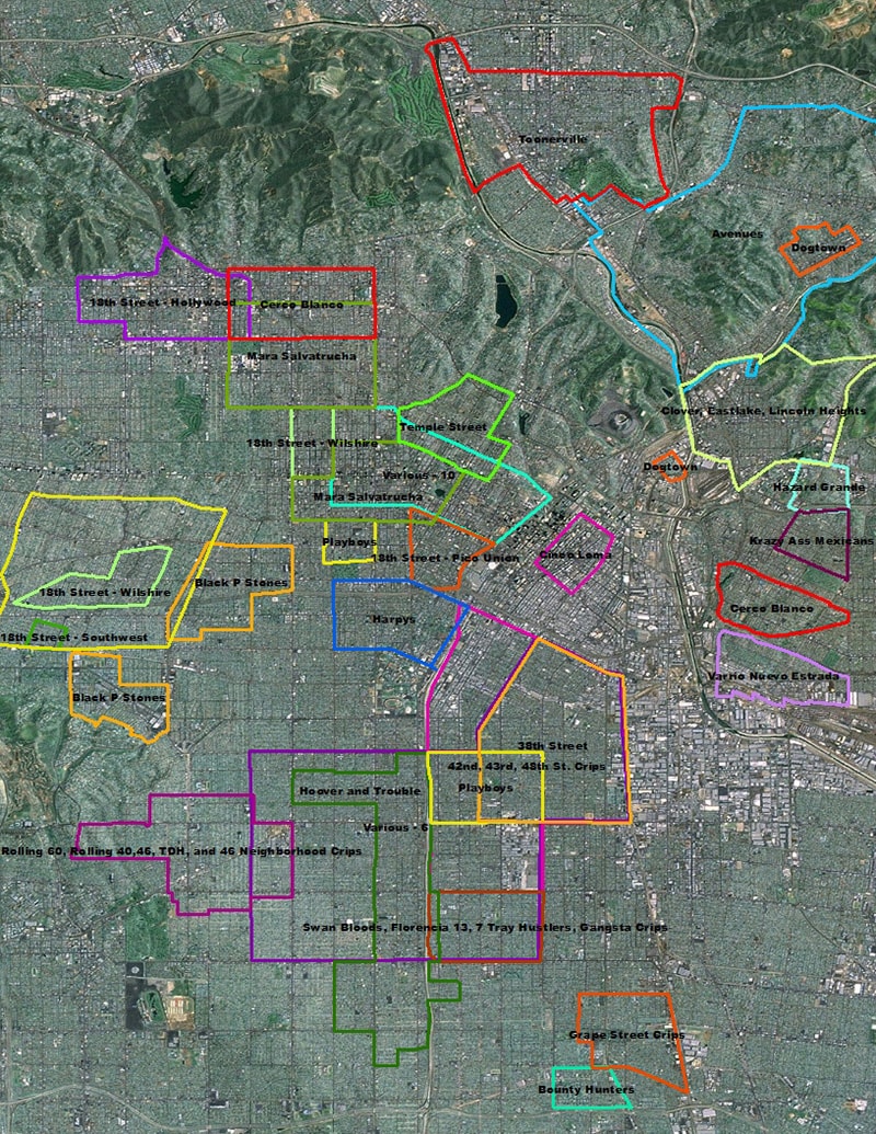
This map shows the boundaries of the injunction zones in central Los Angeles. Note how injunction zones overlap each other, especially in South Central Los Angeles.
Results
Mapping gang injunctions and racial demographic data suggests that gang injunctions are part of a dual spatial strategy: gang injunctions disproportionately target and impact Black and Brown youth; and gang injunctions are placed on the borderlands between racially segregated neighborhoods to police and maintain historical patterns of spatial segregation, to speed up new patterns of race-based displacement, and to enforce new patterns of spatialized racial segregation. Mapping total homicides for 2011 within existing injunction zones suggests that gang injunctions have been ineffective at reducing violent crime: geographic areas with overlapping injunctions continue to coincide with high-density homicide areas. Mapping incidents of police officer “use of deadly force” with existing injunction zones suggests that injunction zones operate as militarized zones in which police officers have increased license or propensity to use deadly force:
- 65 out of 143 people killed by police officers between 2007–2011 in LA County were killed within gang injunction “safety zones,” indicating that people living in gang injunction zones are disproportionately impacted by police use of deadly force
- 19 out of 32 police killings in LA County in 2011 were within gang injunction zones
- 92 percent of police killings of community members between 2007–2011 in LA County were of people of color, indicating that people of color are disproportionately impacted by gang injunction policing
- 50 percent of people killed by police in LA County between 2007–2011 were under the age of 26, indicating that youth are disproportionately impacted by police violence
- 97 percent of people killed by police in LA County between 2007–2011 were people categorized as men, indicating that men of color are disproportionately subjected to police use of deadly force
Our results also indicate that gang injunctions function as a form of gendered discipline and punishment. In particular, gang injunctions operate as one of many disciplinary techniques of policing that target young Black and Brown men for death in LA County. Gang injunctions also function to criminalize and suppress whole neighborhoods and communities, in effect disappearing people from any visible neighborhood social life outside of the home, shelter, or jail. In this way, we can see the how the spatialization of race, via management strategies like gang injunctions, marks the occasion of gender’s undoing. Criminal discourses are already undergirded by racist ideology that is premised on the already non-normativity of racialized genders. Gang injunctions are a part of an arsenal of racist strategies of spatial management that throw normative gender and gendered relations into constant crisis in neighborhoods and communities that have experienced the abandonment characteristic of neoliberal capitalism. The reality of heightened policing turns neighborhood spaces of sociality into potential scenes of regulation. Curfew laws flip gendered scripts about who is confined to or by the domestic or home sphere. When entire neighborhoods face enhanced surveillance and monitoring, all people regardless of gender are increasingly vulnerable to interaction with law enforcement.
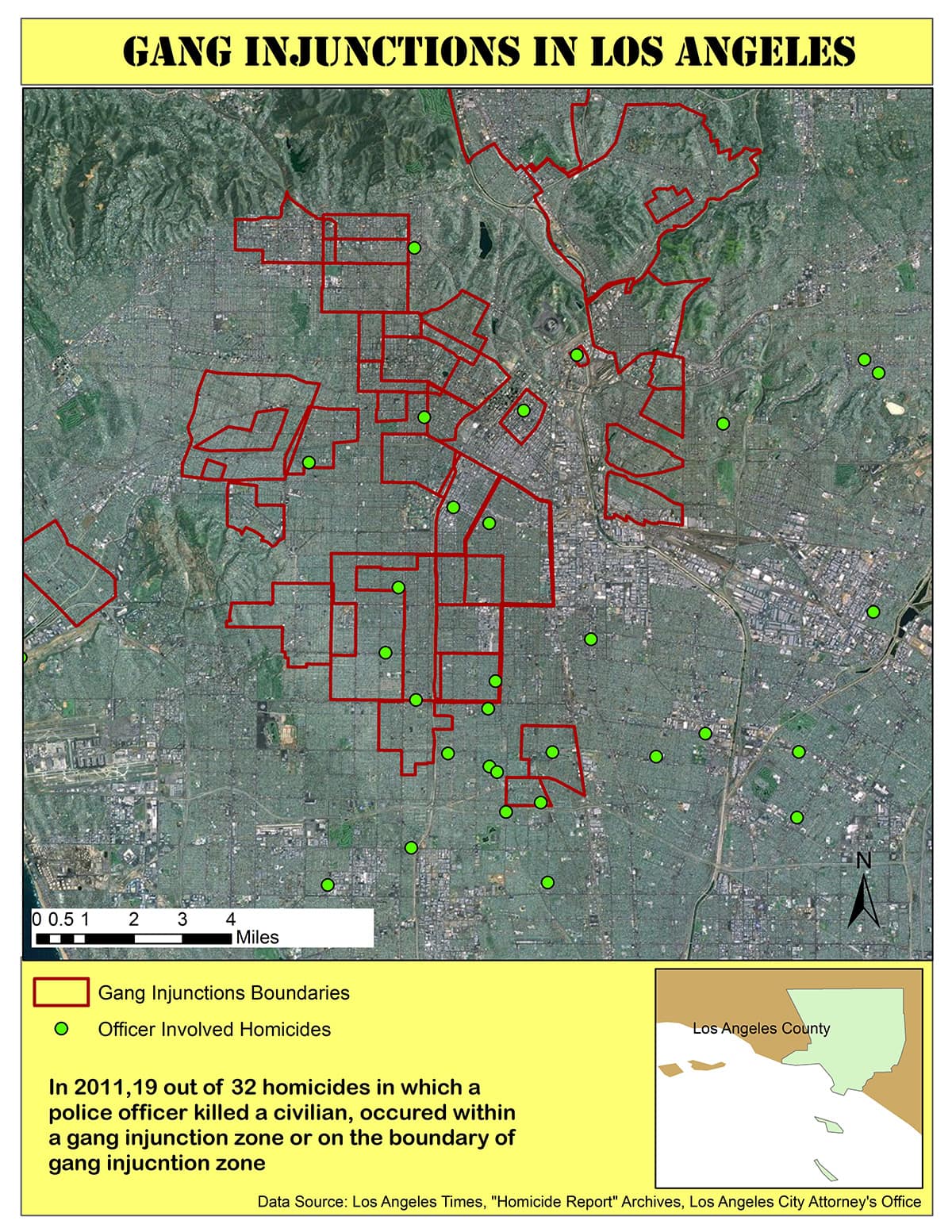
This map shows injunction zones boundaries alongside law enforcement involved shootings in 2011. Over half of officer involved shootings in 2011 occurred in or near an injunction zone.
Spatial video was particularly useful in bringing attention to the complicated ways that gang injunctions enforce gendered violence and undo normative gender spatial associations. For example, the theme of absence stood out in the spatial video narrative of the Hyde Park neighborhood, where there is a gang injunction against the Rolling 60s Crips. One of the narrators remarked that the quiet, seemingly empty streets used to be filled with people and activity before the gang injunction was effected. Now, streets are empty because people are afraid to be outside for fear of encounters with law enforcement. Another narrator pointed out an intersection at West and Hyde Park Boulevard, where several young people who had come to YJC over the years were recently killed.
In this collaborative project, combining GIS with ethnographic techniques created spatial counter-narratives that challenge common-sense notions of what safety means and looks like. By collecting narrative and visual data from community members most impacted by mass imprisonment and state abandonment, we can highlight the everyday impact of this neglect and displacement.
Conclusion
The extensive use of GIS to manage and grow the prison-industrial complex does not foreclose its potential use to challenge that growth. If anything, it demands that scholars, activists, and community members interested in more livable social and economic relationships and spatial arrangements devise creative strategies to displace the totalizing spatial narratives of the PIC.
In this moment of heightened and continued uprising across the US against police terror and violence, we offer our collaborative data collection and mapping about suppressive police tactics and the people and populations they target for state violence, abandonment, and premature death. We recognize that data collection alone does not matter without organized community-based movements to mobilize counter-narratives and challenge state violence, including state-sanctioned killing. We urge you to learn more about and support the work of the Youth Justice Coalition, our partner in this project.
- A. Muniz, “Maintaining Racial Boundaries: Criminalization, Neighborhood Context, and the Origins of Gang Injunctions,” Social Problems 61.2 (2014): 216–236.[↑]
- Youth Justice Coalition. “Tracked and Trapped: Youth of Color, Gang Databases, and Gang Injunctions,” December 1, 2012.[↑]
- Jaishankar Karuppannan, “Mapping and Corrections: Management of Offenders with Geographic Information Systems,” Corrections Compendium 30.1 (2005): 1–10.[↑]
- Tony Gubesic, Elizabeth Mack, and Alan T. Murray, “Geographic Exclusion: Spatial Analysis for Evaluating the Implications of Megan’s Law,” Social Science Computer Review 25.2 (2007): 143–162; Karuppannan, “Mapping and Corrections.”[↑]
- Karuppannan, “Mapping and Corrections.”[↑]
- Mei-Po Kwan, “Feminist Visualization: Re-envisioning GIS as a Method in Feminist Geographic Research Annals of the Association of American Geographers,” Annals of the Association of American Geographers 92.4 (2002): 645–661.[↑]
- Michel de Certeau, The Practice of Everyday Life, trans. Steven F. Rendall (Berkeley: University of California Press, 1984).[↑]
- Henri Lefebvre, The Production of Space (Padstow, Cornwall: Blackwell Publishing Ltd., 1991).[↑]
- Youth Justice Coalition, “Don’t Shoot to Kill: Homicides Resulting from Law Enforcement Use of Force Within LA County, 2000-2014,” January 1, 2014.[↑]